The best drones for surveyors are not the ones with the flashiest marketing claims. They are the aircraft and sensor systems that match your deliverables, your accuracy workflow, your crew skill, and the amount of ground you need to cover in a day. If you are trying to choose the best drones for surveyors based on budget, skill level, and real use cases, start with the job first and the airframe second.
Quick Take
If you want the short answer, here it is:
- Best overall for most surveyors: DJI Mavic 3 Enterprise
- Best used-budget option: DJI Phantom 4 RTK, but only if local batteries, parts, and support are still easy to get
- Best enterprise photogrammetry upgrade: DJI Matrice 350 RTK with Zenmuse P1
- Best for vegetation, complex terrain, and LiDAR-driven workflows: DJI Matrice 350 RTK with Zenmuse L2
- Best for large-area mapping: WingtraOne GEN II
Just as important:
- Buy the workflow, not just the drone
- A low sticker price can become expensive if you still need batteries, RTK or PPK support, software, training, and ground control equipment
- RTK is not magic and LiDAR is not magic
- A drone can support survey work, but it does not automatically replace licensed ground survey methods or legal sign-off requirements in your jurisdiction
Best Fit by Buyer Profile
| Buyer profile | Best fit | Why it fits | Main risk |
|---|---|---|---|
| Solo surveyor or small firm doing topo, stockpiles, and construction progress | DJI Mavic 3 Enterprise | Portable, capable, mapping-focused, easier to learn and deploy daily | Can feel small once project size and throughput increase |
| Cost-sensitive buyer entering drone mapping | Used DJI Phantom 4 RTK | Proven mapping platform if you find a good local used ecosystem | Aging batteries, aging support, and long-term platform risk |
| Established firm scaling photogrammetry output | DJI Matrice 350 RTK + Zenmuse P1 | Higher throughput, stronger enterprise workflow, better fit for larger or more demanding jobs | Higher upfront cost and more operational complexity |
| Survey team dealing with vegetation, corridors, or difficult ground models | DJI Matrice 350 RTK + Zenmuse L2 | LiDAR helps where image-only mapping struggles | Expensive, heavier data processing, and still needs careful QA |
| Large rural sites, mines, quarries, or long corridor jobs | WingtraOne GEN II | Covers more ground efficiently | Fixed-wing workflow is less forgiving on tight or obstacle-rich sites |
What Surveyors Should Decide Before Comparing Drones
A lot of bad purchases happen because buyers shop by brand, camera resolution, or social media buzz. Surveying needs a stricter checklist.
1. Define the deliverable first
Ask what you are actually being paid to produce:
- Orthomosaic
- 3D point cloud
- Surface model
- Terrain model
- Stockpile volumes
- Progress tracking
- Corridor mapping
- As-built documentation
- Vegetation-affected terrain model
- Utility or infrastructure mapping
If most of your work is small construction sites and stockpiles, you do not need the same platform as a team mapping long rural corridors or forested terrain.
2. Decide how accurate the result needs to be
You need two answers:
- What accuracy does the project require?
- How will you prove it?
This is where terms like these matter:
- RTK: real-time kinematic correction applied during flight
- PPK: post-processed kinematic correction applied after flight
- GCPs: ground control points surveyed on the ground
- Checkpoints: independent ground points used to verify final accuracy
A drone can help you get excellent results, but accuracy depends on the full workflow, not just the aircraft.
3. Be honest about site size
Site size decides whether you need a compact multirotor or a larger system.
- Small to medium sites: compact mapping drones are usually enough
- Bigger sites or higher daily coverage demands: enterprise multirotors or fixed-wing systems make more sense
- Very large rural areas: fixed-wing often wins on efficiency
A drone that is perfect for a five-hectare construction site may be painfully slow on a mine or long corridor project.
4. Check terrain, texture, and vegetation
Photogrammetry means building measurements from overlapping images. It works very well when the scene has good texture and clear visibility.
It works less well when you have:
- Dense or uneven vegetation
- Low-texture surfaces
- Repetitive patterns
- Highly reflective surfaces
- Complex vertical geometry
That is where LiDAR or higher-end workflows start to justify their cost.
5. Match the platform to crew skill
A good buyer question is not just “What is the best drone?” It is “What can my crew operate consistently and correctly?”
- Beginner to intermediate teams usually do better with a compact multirotor
- Experienced crews can benefit from larger enterprise aircraft
- Fixed-wing gives you efficiency, but asks more from planning, site assessment, and operator discipline
6. Check your software stack before you buy
Your aircraft needs to fit your processing and deliverable workflow.
Think about whether your team already uses tools such as:
- Pix4D
- Agisoft Metashape
- DJI Terra
- DroneDeploy
- Propeller
- Trimble workflows
A cheaper aircraft is not cheaper if it creates problems in processing, QA, or client delivery.
7. Price the whole kit, not the aircraft
Survey buyers often focus too hard on the airframe and forget the rest:
- Extra batteries
- Charger setup
- RTK module or correction workflow
- GNSS rover or survey control workflow
- Ground targets
- Processing software
- Cloud storage
- Field tablets
- Cases and transport
- Training
- Insurance
- Spare props and maintenance
For survey work, the drone is only part of the system.
Budget Bands That Actually Matter
Exact pricing varies a lot by country, distributor, taxes, software, and bundle choices, so it is better to think in broad bands than live street prices.
| Budget band | What it usually means | Best fit |
|---|---|---|
| Under roughly $5,000 | Usually only realistic through used gear, rentals, or a very lean entry setup | Used Phantom 4 RTK if support is strong, otherwise rent or subcontract |
| Roughly $5,000 to $15,000 | Sweet spot for a serious small-business mapping setup including essentials | DJI Mavic 3 Enterprise ecosystem |
| Roughly $15,000 to $40,000+ | Enterprise photogrammetry or fixed-wing mapping systems | Matrice 350 RTK + P1, or WingtraOne GEN II |
| $40,000+ | LiDAR-capable systems and higher-end enterprise workflows | Matrice 350 RTK + L2 and similar advanced setups |
One honest point: if your budget only covers the aircraft but not the workflow, you may be better off renting, partnering, or subcontracting until the numbers work.
The Best Drones for Surveyors by Real Use Case
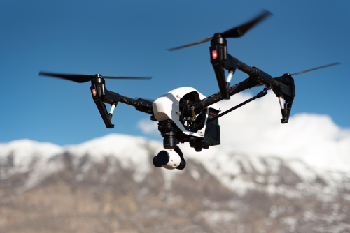
DJI Mavic 3 Enterprise
Best overall for most surveyors
For many surveyors, this is the smartest buy.
Best for
- Small to medium topographic mapping jobs
- Construction progress
- Stockpile volumes
- Quarry updates
- Site documentation
- Small crews and solo operators
- Firms entering paid drone mapping without jumping straight to enterprise-heavy systems
Why it stands out
The Mavic 3 Enterprise hits the sweet spot between portability, mapping capability, and operational simplicity. It is the kind of drone that can live in a truck, be deployed quickly, and still produce serious commercial outputs when used with proper control and processing.
Its biggest strengths are practical:
- Portable and fast to deploy
- Easier learning curve than larger enterprise systems
- Good fit for daily field use
- Mapping-focused camera design
- Strong ecosystem support in many markets
- Lower transport and setup burden than big multirotors
If most of your revenue will come from construction, small land development, stockpiles, and frequent repeat visits, this is usually the best first serious purchase.
Who should buy it
- Surveyors starting or expanding drone services
- Construction-focused survey teams
- Civil and sitework firms that need regular aerial updates
- Operators who want a business tool rather than a hobby drone
Who may outgrow it
- Teams covering large sites every day
- Firms needing interchangeable payloads
- Buyers who already know they need LiDAR
- Corridor or vegetation-heavy projects where image-only mapping will struggle
Buyer regret risk
The main regret with the Mavic 3 Enterprise is not that it is bad. It is that some firms buy it when they already know their real workload points toward large-site enterprise photogrammetry or LiDAR.
If your jobs are mostly moderate-sized and repeatable, it is a strong buy. If your jobs are large, complex, or vegetation-heavy, it may become your “starter drone” rather than your long-term main platform.
DJI Phantom 4 RTK
Best used-budget option, not the best long-term new-business platform
The Phantom 4 RTK still shows up in serious mapping conversations because it proved itself on real projects for years. It can still be a practical buy on the used market, but only with caution.
Best for
- Tight budgets
- Buyers who already know the platform
- Firms with access to local used parts, batteries, and repair support
- Internal mapping workflows where platform age is acceptable
Why it still matters
The Phantom 4 RTK helped set the standard for accessible mapping workflows. Many teams know exactly how to fly it, process it, and QA the output.
That matters. A known workflow is valuable.
Why you should be careful
This is an older platform. That means:
- Battery availability matters
- Spare parts matter
- Local repair support matters
- Long-term fleet planning matters
If you are buying one because the price looks good, make sure you are not buying into a support problem. An older “cheap” drone can become expensive when downtime starts hurting project schedules.
Practical advice
Buy a used Phantom 4 RTK only if all of these are true:
- You have a trusted seller
- Battery health is verified
- Local support still exists
- Your workflow does not depend on long-term expansion around that platform
If not, you are usually better off saving for a newer mapping platform or renting when needed.
DJI Matrice 350 RTK with Zenmuse P1
Best enterprise photogrammetry upgrade
Once you move beyond compact mapping drones, the buying decision becomes more about sensor system and business throughput than simple portability. The Matrice 350 RTK paired with the Zenmuse P1 is a strong enterprise photogrammetry setup for firms that need more capacity and flexibility.
Best for
- Larger topographic surveys
- Higher-volume construction and civil work
- Mining and quarry operations
- Firms that need a more scalable survey fleet
- Teams that want an interchangeable enterprise platform
Why it stands out
This setup makes sense when your business is already proving the need for more throughput, more endurance in demanding field operations, and a platform that can grow with broader enterprise work.
Key advantages include:
- Better fit for larger and more demanding jobs
- Enterprise-grade workflow
- Stronger scaling potential than compact drones
- Payload flexibility across broader operations
- Good choice when survey volume justifies a bigger system
What you are really buying
You are not just buying a drone. You are buying:
- Higher job capacity
- Better fleet standardization
- More serious enterprise field workflow
- A platform that can support multiple mission types
Main tradeoffs
- More expensive
- Heavier and more complex to transport
- Longer training ramp for new crews
- Bigger operational footprint
- In some countries, larger aircraft classes can trigger stricter operating requirements, so verify local rules before purchase
This is the right move when the Mavic-class workflow is making you money but also starting to limit you.
DJI Matrice 350 RTK with Zenmuse L2
Best when photogrammetry alone is not enough
If your survey work involves vegetation, uneven terrain, corridor complexity, or surfaces that image-based mapping handles poorly, LiDAR becomes a serious buying question.
That is where the Matrice 350 RTK with Zenmuse L2 enters the conversation.
Best for
- Vegetation-affected terrain work
- Utility corridors
- Forestry-adjacent survey work
- Complex terrain models
- Sites where photogrammetry struggles to produce dependable ground representation
- Buyers who already understand the cost and processing demands of LiDAR
Why it stands out
LiDAR uses laser pulses to measure surfaces directly. In survey workflows, that can help produce more usable terrain information in conditions where RGB photogrammetry has trouble.
That does not mean LiDAR sees through everything or removes the need for control. It means it can be the better tool when:
- Ground visibility is inconsistent
- Terrain is irregular
- Surface texture is weak
- Site geometry is more complex than simple nadir mapping likes
Who should buy it
- Established firms with recurring vegetation or corridor jobs
- Buyers who already know their image-only workflow is the bottleneck
- Teams prepared for heavier data processing and stronger QA discipline
Who should not buy it
- New buyers chasing “better tech” without a defined LiDAR need
- Construction-only teams doing standard open-site mapping
- Firms without a plan for processing, validation, and training
LiDAR is powerful, but it only pays for itself when the problem actually needs LiDAR.
WingtraOne GEN II
Best for large-area mapping
For big-area survey work, fixed-wing efficiency becomes hard to ignore. The WingtraOne GEN II is a strong option for teams that need to cover more ground per mission than a multirotor comfortably can.
Best for
- Large rural mapping
- Mines and quarries
- Agriculture-scale land coverage
- Corridor sections where efficient coverage matters
- Teams that value VTOL fixed-wing efficiency
Why it stands out
Fixed-wing systems usually win when area coverage is the main bottleneck. The Wingtra approach gives you that efficiency without the full runway-style launch and recovery demands of traditional fixed-wing aircraft.
That makes it especially attractive for:
- Large properties
- Sparse rural operations
- Projects where daily coverage matters more than tight-site maneuvering
Main tradeoffs
- Less ideal for tight urban or obstacle-heavy environments
- More mission-planning discipline required
- Not the easiest first platform for brand-new operators
- Operational style is different from the multirotor workflows most small teams start with
If your main frustration is “our current drone is too slow for the amount of ground we must map,” a fixed-wing platform deserves serious attention.
If Your Organization Cannot Buy DJI
Some companies, public agencies, and infrastructure operators have procurement, security, or policy restrictions around certain manufacturers. If that applies to you, do not force a consumer-style workaround.
Prioritize these features instead:
- Mechanical shutter or other mapping-appropriate image capture
- RTK or PPK support
- Strong mission-planning workflow
- Clean export into your processing stack
- Regional distributor and repair support
- Battery availability
- Data handling that matches your organization’s policy
In that situation, support quality and workflow fit matter more than chasing a headline brand.
Safety, Legal, and Operational Risks to Verify Before You Buy
Survey drones operate in regulated airspace, on active job sites, and often near people, roads, equipment, utilities, or private property. Before you buy, verify the rules that apply in the countries and project environments where you will actually work.
Check at least these areas:
- Pilot certification or competency requirements
- Aircraft registration rules
- Commercial operation requirements
- Airspace authorizations
- Rules for flying near infrastructure, roads, rail, industrial sites, or populated areas
- Whether larger aircraft classes trigger stricter operating conditions in your jurisdiction
- Privacy and property-related restrictions for aerial data capture
- Insurance expectations for commercial jobs
- Whether local surveying law limits who can certify or sign off official survey outputs
Operationally, also plan for:
- Wind limits and weather margins
- GNSS interference or multipath near steel, concrete, and heavy infrastructure
- Safe takeoff and landing zones
- Battery management on long field days
- Redundant QA using checkpoints, not just RTK confidence
A drone purchase is a compliance purchase too.
Common Mistakes Survey Buyers Make
Buying a camera drone instead of a survey workflow
A good camera does not automatically make a good mapping system. Survey work needs repeatable mission planning, dependable geotagging, and a clean processing path.
Assuming RTK removes the need for ground control
RTK can reduce ground control needs. It does not remove the need for independent validation. Checkpoints still matter.
Expecting photogrammetry to solve vegetation-heavy terrain jobs
It can do a lot, but vegetation is still where many buyers discover the limits of image-only workflows.
Buying LiDAR because it sounds more advanced
If your work is mostly open construction sites, stockpiles, and standard topo jobs, LiDAR may be a very expensive way to solve a problem you do not have.
Starting with fixed-wing when your crew is still learning basics
Fixed-wing efficiency is real, but so is the extra planning burden. Many teams are better served by mastering multirotor workflows first.
Underbudgeting software and support
The aircraft is the exciting part. The real business costs often sit in processing, storage, support, and downtime.
Forgetting that survey law and aviation law are different things
Being allowed to fly a drone does not automatically mean you are allowed to certify or represent every result as an official survey deliverable. That depends on local professional rules and project scope.
FAQ
What is the best first drone for a small surveying business?
For most small firms, the DJI Mavic 3 Enterprise is the best first serious purchase. It gives you a practical balance of portability, mapping capability, and manageable operating complexity without pushing you into a full enterprise-heavy setup too early.
Is a used Phantom 4 RTK still worth buying?
Sometimes, yes. It can still be a good value if batteries, repair support, and local workflow knowledge are easy to access. If support is weak or battery supply is uncertain, it is usually safer to avoid building a new business around an older platform.
Do I need RTK if I already use ground control points?
Not always, but RTK is still valuable. It improves geotag accuracy, can reduce field time, and makes workflows more efficient. Ground control and checkpoints still matter, especially when accuracy requirements are strict.
When is LiDAR worth paying for?
LiDAR is worth it when vegetation, complex terrain, or low-texture environments are regularly hurting your photogrammetry results. If most of your work is open-site mapping, stockpiles, or standard construction documentation, the extra spend may not pay back quickly.
Should I buy a fixed-wing drone or a multirotor?
Buy a multirotor if your work is mostly small to medium sites, urban or tight locations, and frequent repeat missions. Buy fixed-wing when large-area coverage is the bottleneck and your team is ready for the different planning and field workflow it requires.
Can a standard consumer camera drone be used for surveying?
It can be used for rough internal mapping or visual documentation, but that is different from buying a true survey workflow. For professional deliverables, especially paid work, a mapping-oriented platform is the better choice.
Does drone data replace a legal boundary survey?
Not by default. Drone data can be extremely useful for mapping, measurement, planning, and progress documentation, but legal boundary work and certified survey outputs often have separate professional and regulatory requirements. Verify what is allowed in your jurisdiction before promising deliverables.
What else should I budget for besides the drone?
Plan for batteries, chargers, cases, RTK or PPK workflow, control points, processing software, data storage, field devices, training, insurance, and spare parts. Many buyers underestimate these costs and then wonder why the “affordable” drone does not feel affordable.
The Buying Decision That Usually Holds Up Best
If most of your work is construction topo, stockpiles, site progress, and small-to-medium mapping jobs, the safest choice is usually the DJI Mavic 3 Enterprise. If you are stretching to cover bigger sites and more output volume, step up to Matrice 350 RTK with P1. If vegetation and terrain complexity are the real problem, move to Matrice 350 RTK with L2. And if your main bottleneck is area coverage, look hard at WingtraOne GEN II.
If your budget cannot support the full workflow, do not buy the wrong drone just to get airborne. Rent, partner, or subcontract first, then buy when you can afford the aircraft, the control workflow, the software, and the QA needed to stand behind your deliverables.