Forestry work is one of the fastest ways to discover whether you bought the right drone or just a nice camera that flies. Wind over the canopy, weak GPS under trees, long hikes to launch points, and the need for clean, repeatable data all make forests tougher than open-field flying. The best drones for forestry work depend on what you actually need to deliver: simple scouting, creator-grade visuals, accurate maps, thermal checks, or enterprise LiDAR data.
Quick Take
If you want the short version, here are the strongest forestry drone picks by buyer type.
| Buyer type | Best pick | Why it fits | Main limitation |
|---|---|---|---|
| Beginner landowner or first-time operator | DJI Mini 4 Pro | Easy to carry, easy to learn, strong basic photo/video scouting | Limited in wind, not a serious mapping platform |
| Beginner who wants room to grow | DJI Air 3 | Better endurance and wind handling, dual-camera flexibility | Still not the best choice for professional mapping deliverables |
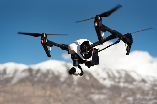
| Creator documenting forestry, conservation, or travel | DJI Mavic 3 Pro | Excellent image flexibility and polished video output | You pay for camera performance more than survey workflow |
| Small business or consultant doing mapping and inspection | DJI Mavic 3 Enterprise | Best balance of portability, mission capability, and commercial output | No LiDAR, and thermal requires a different variant |
| Forestry teams needing thermal | DJI Mavic 3 Thermal | Portable thermal plus visible imaging for inspections and response support | Thermal cannot “see through” dense canopy |
| Enterprise forestry, terrain, and advanced data capture | DJI Matrice 350 RTK with Zenmuse L2 or P1 | Serious payload options, LiDAR path, stronger field platform | Expensive, heavier, more training and workflow complexity |
| Very large-area survey teams | WingtraOne GEN II or senseFly eBee X | Fixed-wing efficiency for big coverage | More planning, launch/recovery complexity, not ideal for every site |
Key Points
- The right forestry drone is chosen by output first, not by brand hype.
- A great video drone is not automatically a great forestry work drone.
- RGB cameras cannot reliably see ground beneath dense canopy.
- For mapping, a mechanical shutter and RTK matter more than cinematic features.
- For dense vegetation and terrain models, LiDAR may be worth the jump.
- Battery logistics, charging, and repair support matter more in forests than many buyers expect.
- Obstacle sensing helps, but it does not make branch-filled or sub-canopy flying safe.
Start with the job, not the drone
Before you compare models, define what “forestry work” means in your case.
If you need visual scouting and field awareness
Typical tasks:
- storm damage checks
- road and trail condition review
- boundary awareness
- regeneration progress photos
- simple before-and-after documentation
You can do this well with a capable RGB drone. Portability, wind handling, and a dependable camera matter most.
If you need content and storytelling
Typical tasks:
- conservation project coverage
- client marketing for forestry companies
- tourism and eco-lodge content
- NGO reporting
- educational or documentary work
You want better image quality, flexible focal lengths, and reliable video performance. You do not necessarily need enterprise mapping features.
If you need maps and measurable outputs
Typical tasks:
- orthomosaics
- digital surface models
- compartment mapping
- road and access planning
- harvest planning support
- client-ready survey-style deliverables
This is where a lot of buyers make the wrong choice. For photogrammetry, which is the process of turning overlapping photos into a map or 3D model, repeatable capture matters more than cinematic features. A mechanical shutter, mission planning, and RTK or PPK-grade positioning can matter a lot.
If you need thermal
Typical tasks:
- hotspot checks by authorized teams
- search support
- perimeter inspection
- equipment heat monitoring
- controlled-burn assessment where legally authorized
Thermal is useful, but it is not magic. It does not give you a perfect forest X-ray, and canopy can hide what is below.
If you need terrain under vegetation
Typical tasks:
- advanced inventory support
- terrain modeling in wooded areas
- engineering and road design support
- larger-scale professional forestry analysis
This is where LiDAR starts to justify its cost. LiDAR uses laser pulses to capture 3D structure and can often recover ground information through gaps in vegetation much better than standard photo mapping.
The best drones for forestry work, by real buyer fit
DJI Mini 4 Pro
Best for beginners, landowners, students, and lightweight scouting
The Mini 4 Pro is the easiest honest recommendation for someone who needs to start small. It is light, compact, fast to deploy, and good enough for many forestry-adjacent tasks like access road checks, storm review, and general visual documentation.
Why it works
- Very portable for hiking and remote access
- Strong enough camera for basic documentation and social content
- Easier learning curve than larger aircraft
- In many jurisdictions, sub-250 g drones may face a lighter regulatory burden, though rules still vary and must be checked
Where it falls short
- Wind above the canopy can push it around more than larger drones
- It is not the right tool for professional mapping promises
- Small-sensor performance is less forgiving in harsh light
- Remote forestry work can expose its battery and range limitations faster than casual users expect
Buy it if
- You are new to drones
- You mostly need daylight visuals, not survey accuracy
- You want the lightest travel-friendly forestry option
Skip it if
- You plan to sell mapping services
- You routinely fly in windy upland or ridgeline conditions
- You already know you will need thermal or LiDAR
DJI Air 3
Best all-round step-up pick for serious beginners and forestry creators
The Air 3 is a strong middle-ground buy. It is more capable in the field than a Mini, offers dual-camera flexibility, and stays portable enough for remote work. For forestry creators, NGOs, ecotourism operators, and small teams doing visual monitoring, it hits a sweet spot.
Why it works
- Better wind handling and endurance than Mini-class drones
- Wide and medium tele cameras help with both context and tighter shots
- Good for visual inspections without flying too close to treelines
- A sensible choice for buyers who want one drone for both field work and polished content
Where it falls short
- It is still not a mapping-first platform
- No true enterprise survey workflow advantage
- If your business depends on measurable outputs, you will outgrow it faster than you think
Buy it if
- You want one capable drone for forestry visuals, inspections, and content
- You hike to sites and care about portability
- You want better performance than a Mini without jumping into enterprise spend
Skip it if
- Your deliverable is a paid orthomosaic or survey product
- You need thermal
- You need higher-end image flexibility for premium client video work
DJI Mavic 3 Pro
Best for forestry creators who prioritize image quality
If your forestry work leans toward visual storytelling, branded campaigns, conservation media, or premium aerial photography, the Mavic 3 Pro is the better creative tool than the Air 3. Its camera flexibility is a real advantage when you need both wide context and more polished compressed perspectives.
Why it works
- Excellent stills and video quality for professional content
- Multiple focal lengths help show scale in forests and mountain terrain
- Better fit for agencies, tourism creators, and documentary-style shooters
Where it falls short
- It is not the smartest pure-workflow buy for mapping businesses
- You pay for creative image quality rather than enterprise data features
- Overkill if your real need is basic scouting
Buy it if
- Your clients care about visual quality and storytelling
- You create films, reports, campaigns, or conservation media
- You want a premium camera drone, not a survey platform
Skip it if
- You mainly need mapping
- Your budget needs to cover RTK, software, and data processing instead
- You work in harsh field conditions where enterprise support matters more than cinematic features
DJI Mavic 3 Enterprise
Best one-drone buy for most professional forestry operators
For many small and mid-size commercial forestry teams, this is the practical winner. The Mavic 3 Enterprise is portable enough to live in a truck or field pack, but serious enough to handle structured mapping and inspection work.
Why it works
- Designed around enterprise workflows rather than consumer filming
- Mechanical shutter is better for mapping than a camera built mainly for video
- RTK support improves positional accuracy when the workflow requires it
- A very strong fit for forestry consultants, survey teams, and service providers who need clean deliverables without moving into heavy-lift aircraft
Where it falls short
- It still cannot do what LiDAR does under canopy
- It is a business tool, not a creator-first platform
- You will need to budget for the full workflow, not just the aircraft
Buy it if
- You sell or plan to sell mapping, inspection, or repeatable site documentation
- You need a portable professional platform
- You want the safest step between consumer drones and heavier enterprise systems
Skip it if
- You mainly shoot cinematic forestry content
- You need thermal as your primary output
- Your projects demand terrain extraction in dense forest
DJI Mavic 3 Thermal
Best portable thermal forestry drone
If your forestry operation specifically needs thermal, the Mavic 3 Thermal is usually the most practical portable option. It gives teams a fast-deploy tool for heat-related inspection tasks without the size and cost jump of a heavy platform.
Why it works
- Combines visible and thermal imaging in a compact package
- Easier to deploy than larger enterprise aircraft
- Useful for public safety support, heat checks, and certain inspection tasks when legally authorized
Important limits
- Thermal does not reliably see through dense canopy
- Thermal success depends heavily on timing, temperature contrast, and scene conditions
- It is not a substitute for LiDAR or formal tree-health science workflows by itself
Buy it if
- Heat detection or thermal inspection is mission critical
- You need a smaller field kit than a Matrice-class aircraft
- Your work includes response support, perimeter checks, or specific thermal tasks
Skip it if
- Your real need is mapping
- You expect thermal to solve dense-canopy visibility problems
- You do not have a clear thermal use case
DJI Matrice 350 RTK with Zenmuse L2 or P1
Best enterprise platform for advanced forestry work
When the job is bigger than “get some pictures” or even “make a map,” this is where serious forestry workflows start. The Matrice 350 RTK platform supports payloads that materially change what you can capture and sell.
Why it works
- Handles high-end sensors and tougher field workflows
- Better platform for teams with trained crews and repeat contracts
- With Zenmuse L2, it opens the door to LiDAR-based wooded terrain capture
- With Zenmuse P1, it supports high-productivity photogrammetry missions
- Better fit for enterprise fleet management, redundancy, and harder-duty operations
Where it falls short
- Much higher upfront and operational cost
- More training, more batteries, more transport planning
- Heavier aircraft means more operational discipline and often more regulatory complexity
Buy it if
- You already have commercial demand for advanced forestry data
- You need sensor flexibility
- You are building a serious survey, engineering, or land-management operation
Skip it if
- You are still learning basic workflows
- You do not have a real market for LiDAR or enterprise mapping
- Portability and simplicity matter more than sensor power
WingtraOne GEN II or senseFly eBee X
Best for very large forestry coverage
Not every forestry team should buy a fixed-wing platform, but for large estates and broad-area mapping, they deserve a place on the shortlist. Fixed-wing aircraft can cover more ground efficiently than multirotors.
Why they work
- Better area coverage for large mapping jobs
- Often more efficient for repeated broad-acre missions
- Strong fit when your business model is acreage and productivity
Where they fall short
- More planning and crew discipline
- Launch and recovery can be trickier depending on terrain
- Not as convenient for spot checks, tight sites, or small irregular jobs
Buy one if
- Your projects are consistently large
- Your team already understands mapping workflow
- Your site conditions support fixed-wing operations
Skip it if
- Most jobs are small, wooded, steep, or awkward to launch from
- You want a single drone for both creative work and inspection
- You are still validating your service demand
How to choose the right forestry drone
1. Match the sensor to the output
Ask this first:
- Do I need photos and video only?
- Do I need measurable maps?
- Do I need heat data?
- Do I need terrain beneath vegetation?
That answer narrows the field fast.
Good rule of thumb
- Visual documentation: Mini 4 Pro, Air 3, Mavic 3 Pro
- Mapping and inspection: Mavic 3 Enterprise
- Thermal: Mavic 3 Thermal
- Dense vegetation and advanced terrain work: Matrice 350 RTK with LiDAR payload
- Huge areas: fixed-wing mapping platform
2. Be honest about acreage and access
Forestry work is not just about flight time. It is about:
- how far you walk to launch
- how many batteries you can carry
- whether you have vehicle access
- how quickly weather shifts
- whether you need to redeploy to multiple compartments in a day
A smaller drone can win if the job is mobile and scattered. A larger system wins if the output justifies the setup time.
3. Do not ignore the software and data burden
The aircraft is only half the purchase.
If you plan to map, also think about:
- mission planning app support
- RTK workflow
- photogrammetry processing
- GIS integration
- storage requirements
- report delivery to clients
A buyer who spends heavily on a drone but underbudgets the software and workflow stack usually regrets it.
4. Check repair support before you buy
Forestry work is hard on equipment. Dust, moisture, rough landings, vehicle transport, and branch strikes happen. Local or regional service support can matter more than a marginal camera upgrade.
Ask:
- Can I get batteries quickly?
- Are props and parts easy to source?
- Is downtime manageable in my market?
- Does my team already know this ecosystem?
5. Budget for the full kit
A forestry drone kit usually needs more than the drone itself.
At minimum, think about:
- spare propellers
- multiple batteries
- charging strategy for field vehicles or remote sites
- landing pad
- controller sunshade or bright-screen controller
- weather-conscious carry case
- memory cards and storage
- RTK accessories if required
- safety gear and checklists
Safety, legal, and operational limits to verify
Forestry flying often looks remote and simple, but it can involve more risk and compliance than buyers expect.
Before flying, verify the rules that apply in your country, region, and specific site, especially for:
- registration and pilot requirements
- remote identification if required
- visual line of sight rules
- beyond visual line of sight restrictions
- operations in protected forests or parks
- flights over private land or near workers and vehicles
- wildfire or emergency-response restrictions
- wildlife disturbance rules
- local land manager or concession-holder permission
A few practical cautions matter everywhere:
- Never assume a forest is “empty.” There may be hikers, workers, vehicles, researchers, or local communities nearby.
- Do not self-deploy near active wildfires unless you are part of the authorized response.
- Obstacle sensing does not guarantee safety near branches, fine twigs, or under-canopy gaps.
- GPS and compass performance can degrade near steep terrain and dense cover.
- Wind can be much stronger above the canopy than it feels at the launch point.
Common mistakes forestry drone buyers make
Buying for camera specs instead of deliverables
The most common regret is buying a beautiful camera drone when the work really requires a mapping platform.
Assuming RGB can solve dense-canopy problems
It cannot. Photo-based models are useful, but they do not replace LiDAR when ground detail beneath vegetation matters.
Overestimating obstacle avoidance
Tree branches, dead twigs, and partial occlusions are exactly where pilots get overconfident.
Underestimating battery logistics
A forest job can involve long hikes, cold mornings, multiple retakes, and slow charging. The drone may be good enough, but the battery plan is not.
Buying thermal without a real thermal workflow
Thermal is valuable, but only when you know what you are trying to detect and when conditions are right.
Ignoring the client workflow
If your clients want GIS-compatible outputs, area calculations, or repeatable maps, a creator drone will often disappoint no matter how nice the footage looks.
FAQ
What is the best drone for forest mapping?
For most small and mid-size professional teams, the DJI Mavic 3 Enterprise is the most practical mapping buy. If your work regularly involves dense canopy, terrain extraction, or higher-end survey deliverables, a Matrice-class platform with LiDAR may be the better long-term choice.
Do I need LiDAR for forestry work?
Not always. LiDAR is worth considering when you need terrain or structure data in wooded areas, or when project value justifies the cost. If you mainly need visual scouting or surface mapping in open areas, it is usually unnecessary.
Is thermal useful in forests?
Yes, but for specific jobs. Thermal can help with hotspot detection, response support, perimeter checks, and some inspection tasks. It is not a magic tool for seeing through dense trees, and it works best when temperature contrast supports the mission.
Can a beginner drone create forest maps?
It can create basic maps in some conditions, especially in open or lightly wooded areas. But if you need commercial-grade accuracy and repeatability, a mapping-focused platform is a safer buy.
Are fixed-wing drones better for forestry?
They are better for very large-area mapping, not for every forestry task. Multirotors are usually better for tight sites, spot checks, creator work, and mixed inspection jobs.
How many batteries should I plan for forestry work?
More than you think. Light scouting may be fine with a small set, but full field days often need enough batteries for multiple launches plus a charging plan in the vehicle or at base. Battery strategy becomes more important as sites get more remote.
What should I verify before flying in forests?
Check aviation rules, landowner or land-manager permission, protected-area restrictions, wildlife sensitivity, any fire-related restrictions, and local privacy or data rules. Forest sites often have both airspace rules and separate land-access rules.
Which forestry drone has the best upgrade path?
For most buyers, the cleanest upgrade path is Mini 4 Pro to Air 3 for visual work, or Air 3 to Mavic 3 Enterprise if you move into paid mapping. If you already know advanced data is the real destination, it is usually better to skip incremental upgrades and budget directly for an enterprise platform.
Final decision
If you are buying your first forestry drone, start with the simplest platform that can produce your actual output reliably. If you are buying for paid work, the safest commercial choice for most operators is the DJI Mavic 3 Enterprise, while creators will usually be happiest with the Air 3 or Mavic 3 Pro. And if your forestry business depends on real under-canopy data, skip the halfway steps and plan for LiDAR from the start.